• Skip to main content
  • Skip to header left navigation
  • Skip to header right navigation
  • Skip to site footer
  • Home
    • Adventures
    • Places
    • Prophets
    • Apparatus
    • Sustainability
  • Explore
    • Your next adventure
    • Your guides
endorfeen

endorfeen

The Media For Sustainable Outdoors.

  • About us
  • Write/ share
  • endorfeen – instagram page
  • enforfeen Facebook page
  • endorfeen twitter page
  • Pinterest

Archives for October 2023

Solo Triumph on Pumori: Lucien Boucansaud’s Daring Ascent

October 30, 2023 by Thomas Viguier

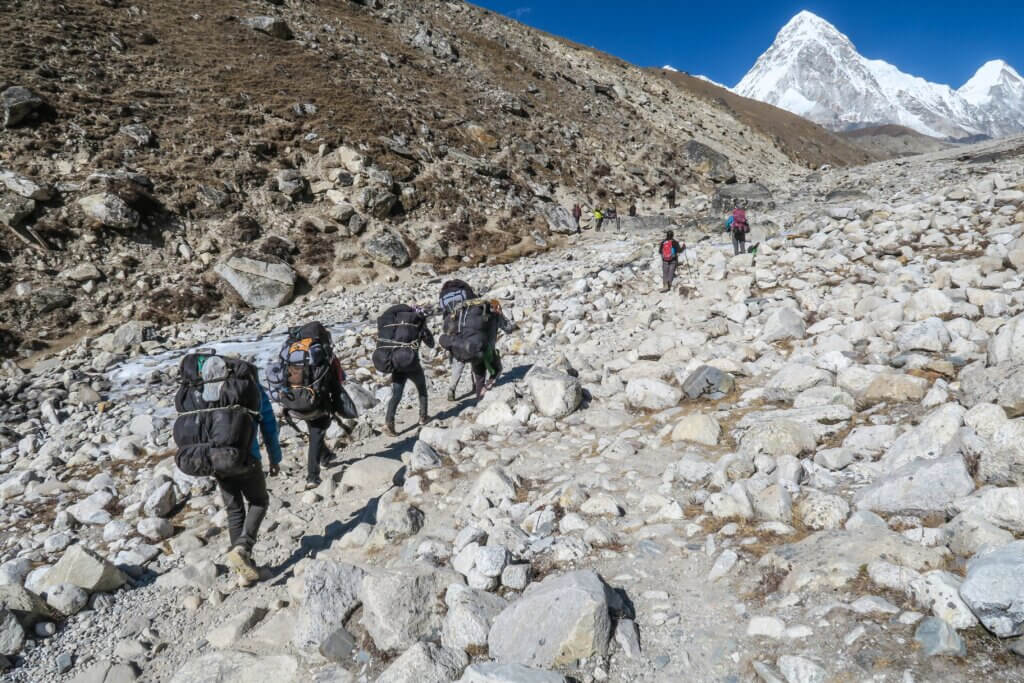
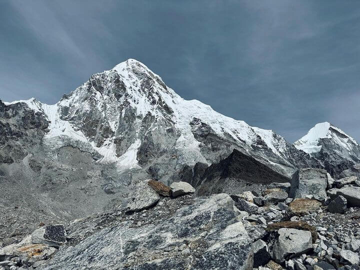
Positioned on the Nepal-China frontier within the expansive Mahalangur stretch of the Himalayas, Pumori stands as a formidable sentinel. Just eight kilometres from the majestic Mount Everest, Pumori, affectionately called “Everest’s Daughter”, captures the imaginations and challenges of climbers worldwide.

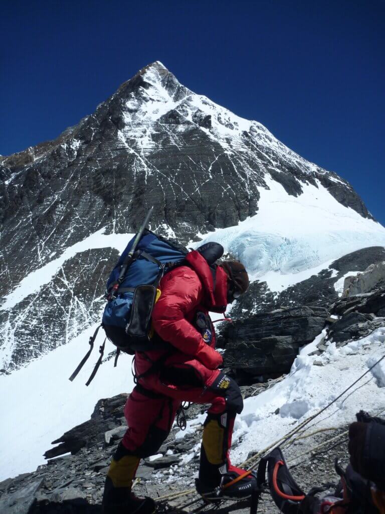
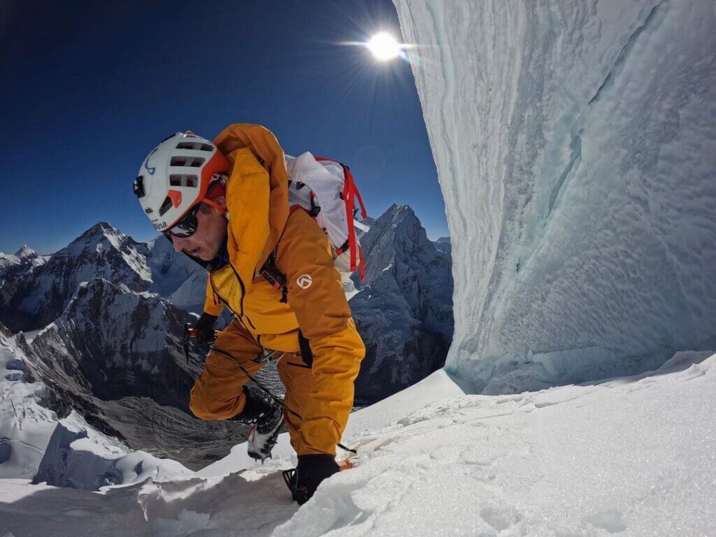
Recently, Lucien Boucansaud, the eminent alpinist, took to Instagram to share his exhilarating experience of scaling this grand mountain. Through sheer grit and determination, Boucansaud achieved what many would consider the pinnacle of mountaineering accomplishments: a solo ascent of Pumori.

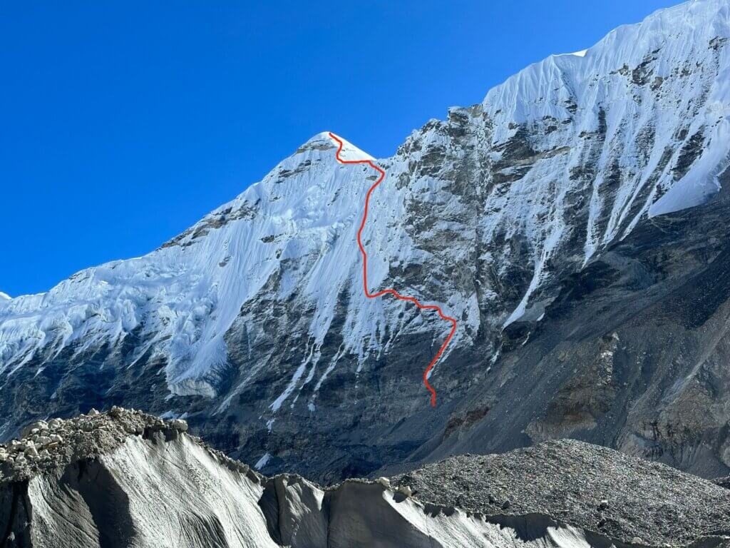
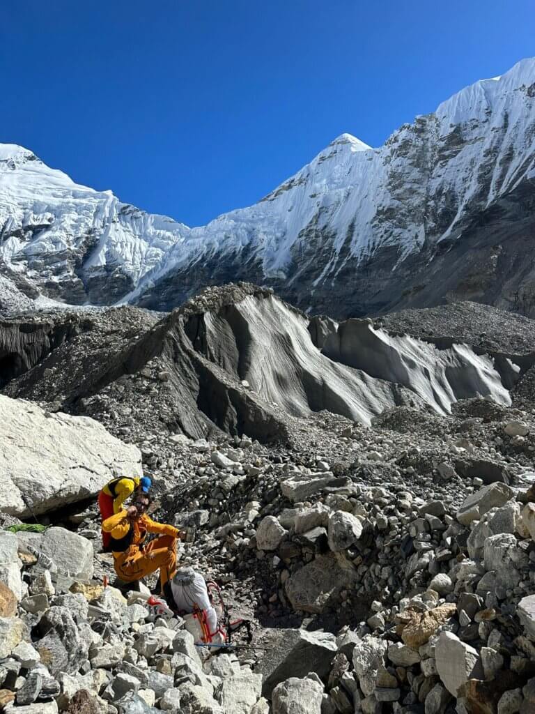
In a heartfelt post, he expressed, “Very happy to have reached the summit of this large, magnificent and dangerous mountain solo. It was not an easy task with a first attempt halted at 6700m due to the risk of a significant avalanche.” Lucien’s choice, the German-Swiss route of 1962, wasn’t a straightforward one. He described it as anything but normal, with the path winding through the southern face and then northeast.

For Boucansaud, achieving this milestone wasn’t just about physical prowess; it was a game of sharp mental acuity. He writes about his deep immersion in the mountain, deciphering its intricacies, and devising a rapid route to sidestep crevices and ice towers. The journey was replete with its share of perils, from crossing an exposed corridor to navigating unstable rock spurs, where every step demanded scrutiny.

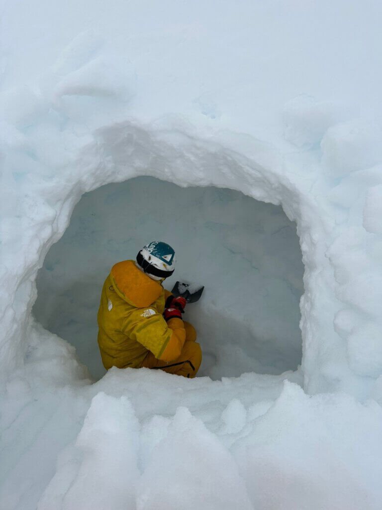
Further challenges awaited as Boucansaud approached the north col at 6600m. Here, he recalls negotiating compact ice walls with steep sections and sharp gradient breaks, often requiring him to scale lightly and later pull up his gear.

One of the most daunting parts of his climb was assessing the avalanche conditions, especially in the mountain’s northeast face. This very threat was the reason behind his earlier aborted attempt at 6700m, with avalanches occurring perilously close to the summit. He muses, “It was as if the mountain wanted to remain unattainable!”

Earlier in October, the renowned Italian mountaineer, Simone Moro, with Sherpas Pemba and Datuk, faced a similar ordeal. Just a mere 100m from the summit, they discerned the pronounced avalanche risk, making a prudent decision to turn back. Tragically, on that same day, several climbers lost their lives on Shishapangma due to an avalanche.

Boucansaud’s account isn’t just about his triumphant ascent but also the discipline and tenacity that shaped his journey. Following his initial thwarted attempt, he emphasized the importance of staying motivated, focused, and seizing the right moment. He meticulously planned, ensuring proper rest, nutrition, and even disconnecting from social media to maintain utmost concentration.

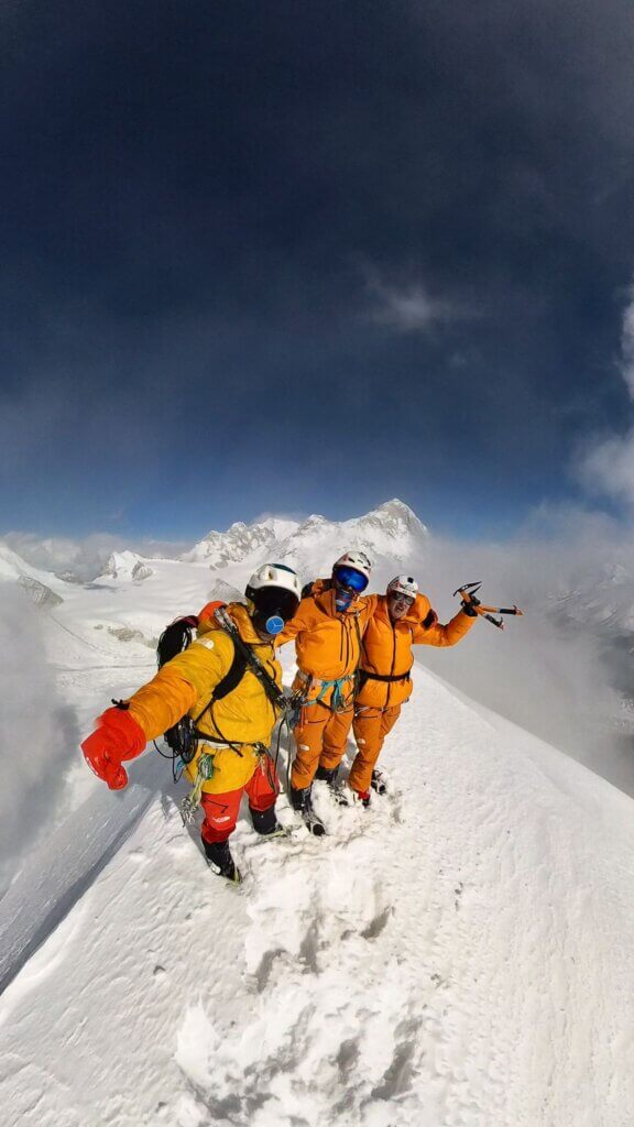
He expresses profound gratitude to David Göttler for his insight, commending his sportsmanship ethos in the Himalayas. Reflecting on his achievement, Lucien wrote, “I am the first and so far the only one this season to reach the Pumori summit following my path. Completely alone on the mountain. An indescribable feeling, my first 7000m with Everest in front of me and, on the other side, the wild view of the Tibetan side and China.”

Documenting his expedition’s timeline, Boucansaud shared that he moved from camp 1 to the summit in just 8 hours and 20 minutes, with a round trip time of 13 hours and 43 minutes. His entire adventure, from Pyramid lodge and back, spanned three days, a remarkable feat for such a challenging peak.

Lucien Boucansaud’s conquest of Pumori is not just a testament to his exceptional mountaineering skills but also an inspiring tale of resilience, strategy, and the relentless human spirit.

How long does it take to climb Mount Everest?

October 25, 2023 by Furqan Javed

The allure of standing atop the world’s highest peak, Mount Everest, has beckoned countless climbers since the landmark achievement of Edmund Hillary and Tenzing Norgay seven decades ago. The 1990s saw the advent of commercial expeditions. Excepting interruptions like the devastating 2015 earthquake and some Covid-affected seasons, the count of climbers has soared.

Despite its burgeoning popularity, the challenge posed by Everest remains immense. Beyond the substantial financial commitment, the physical rigours of ascending to such an altitude are formidable. Killian Jornet’s exceptional double summit in a week without additional oxygen is a rarity. Most climbers must allocate considerable time for their journey to the summit.

How Long does it take to climb Mount Everest?
Khumbu Icefalls, Himalayas, Nepal – © Sebastian Pena Lambarri, Unsplash

A symbol of adventure, captured in numerous films, documentaries, and literary works, Everest’s allure is undeniable. With a height of 8,848.86 metres or 29,0129 feet from sea level, it stands unrivalled as the globe’s tallest point. Its prominence over the world’s second highest, K2, is by a notable 239 metres.

Touted as the pinnacle of adventure pursuits, scaling Everest offers an unparalleled adrenaline surge. But the endeavour is far from straightforward. Successful ascents typically draw on years of mountaineering expertise. Legendary figures like Sir Edmund Hillary, Tenzing Norgay, Scott Fischer, Rob Hall, and others have etched their names in Everest’s history. Climbing its staggering 8,848 metres demands supreme stamina and tenacity. Equally crucial are patience and unwavering determination. For those intrigued by the specifics of such an expedition and the duration it entails, comprehensive insights await.

Traversing to Everest Base Camp: The Essential Trekker’s Overview

Everest Base Camp: Navigating the Ascent and Return

Setting out from Lukla, situated at 2,860 meters above sea level, climbers embark on a journey to reach Everest Base Camp. It usually spans one to two weeks. This initial point is accessible by a modest airport where many mountaineers stock up on essentials and employ porters for assistance.

Those trekking solely to the base camp have the luxury of a slower pace, allowing them to soak in the vistas of varying peaks, quaint villages, and ancient monasteries. However, for those with their sights set on the summit, a significant entourage of porters becomes indispensable, given the volume of equipment and provisions required.

Everest Base Camp Trekking Route, Khumjung 56000, Nepal, Khumjung – © Go Wild

Ascending to the base camp, located at 5,380 meters, is predominantly uphill. As trekkers venture further, they pass through progressively smaller villages, encountering monasteries that sit majestically in the high mountain terrain. Essential items for this trek encompass mountaineering gear, food, cooking apparatus, tents, bedding, and a water source, often derived from melting snow upon reaching the base.

The thinning air at such lofty altitudes proves challenging for many, with breathing becoming laborious, a challenge even during sleep. The risk of altitude sickness is a reality, with reactions varying across individuals.

The descent from the base camp to Lukla, being downhill, is comparatively quicker, taking roughly two to three days. In a bid to expedite their return and aid in the removal of waste, several climbers opt for a helicopter ride back from the base camp.

Aerial Routes to Everest: Helicopters, Planes, and Limits

While helicopters can transport enthusiasts to the Everest Base Camp for sightseeing, reaching the summit this way remains unfeasible. The challenges of landing an aircraft near the peak are insurmountable, given the absence of suitable terrains. Venturing with a helicopter near the perilous “death zone”, situated above 8,000 meters, is widely considered treacherous due to thinning oxygen levels resulting from decreased air pressure. This sparse oxygen not only hampers climbers, necessitating supplemental oxygen, but also impedes helicopters. It makes lift generation and control maintenance nearly unattainable. For conventional aircraft, Lukla town houses the nearest airport, distinguished by its notably brief runway.

Everest Ascent: Phases of the Monumental Climb

The expedition to Mount Everest typically spans between 6 to 11 weeks, with a standard duration of around two months. This time frame accounts for various factors, including the chosen itinerary, the equipment used, the proficiency of the support crew, and the climbers’ own abilities. Prior to embarking on such a monumental quest, one must undertake thorough research, especially regarding weather conditions.

Journeying to Everest begins in Nepal’s capital, Kathmandu. From here, a brief flight transports adventurers to Lukla, known for its intimidating cliffside airport. Following this, there are options to either trek or opt for a helicopter ride to reach the Everest Base Camp.

Once at the base camp, it’s imperative to acclimatise to the significant altitude to avoid severe altitude sickness. Notably, even minor ailments, be it a simple cold or more severe issues like flu or diarrhoea, can escalate due to these conditions, necessitating an emergency evacuation. It’s also worth noting that while Everest straddles the border of Tibet and Nepal, most climbers favour the ascent from the Tibet side.

Preparing and Trekking to Everest Base Camp: The Initial Ascent

Upon arrival in Kathmandu, preparations for the Everest ascent begin immediately. It’s common for climbers to spend about a week in Nepal’s capital. In the bustling tourist hub of Thamel, they gather essential gear and liaise with tour operators. Additionally, they organise the necessary paperwork and permits essential for the Everest summit. This administrative process can have climbers mingling in the vibrant streets filled with cafes, restaurants, and temples as they await the approval of their permits.

How long does it take to climb Mount Everest? Base Camp
Everest Base Camp on a Stormy Day – © Daniel Oberhaus, Wiki Commons

With all formalities completed, the next leg of the journey takes climbers to Lukla, marking the beginning of the ascent towards Mount Everest. The trek from Lukla to Everest Base Camp typically spans 8 to 12 days. This base camp becomes home for several weeks as climbers acclimatise to the challenging altitude. During this acclimatisation period, many utilise the time to summit neighbouring peaks, gradually adjusting their bodies to the reduced oxygen levels at such elevations.

The Everest Base Camp Trek is a path filled with captivating landscapes and cultural landmarks. Along the way, trekkers encounter a variety of attractions, from the world-renowned Lukla airport, known for its extreme landing conditions, to the serenity of alpine forests. The journey also provides glimpses into the vibrant Sherpa community, with stops in places like the bustling Namche Bazaar and the peaceful Tengboche. The combination of a gradual ascent and rigorous preparation sets the stage for the ultimate objective. Once acclimatised and confident, climbers set their sights on the monumental task ahead: the ascent of Mount Everest.

Journey to the Icefall: Navigating Everest’s Perils

After thorough acclimatisation, reaching the Icefall camp typically requires a walk of 3 to 5 hours. Despite the brevity of this route, it’s peppered with hazardous areas, including open crevasses and zones prone to avalanches. To safely navigate these extreme conditions on Mt. Everest, adhering to the guidance of the Sirdar is paramount.

Journey to Camp 1: Navigating Snowy Terrains and Hidden Crevasses

The journey towards Camp 1 traverses a flat, snow-rich terrain marked by unexpected crevasses and imposing rocky walls. Even seemingly minor cracks in the snow’s surface can evolve into perilous crevasses. Therefore, securing oneself to fixed ropes while walking is strongly advised. This stretch typically takes between 4 to 7 hours to navigate.

Approaching Camp 2: The Last Taste of Comfort at 6800 m

On this day of the ascent, the peak of Mount Everest becomes distinctly visible to trekkers. Regrettably, this is the final campsite where climbers can expect properly prepared meals. To aid in acclimatisation at such a lofty altitude, a day’s walk towards Lhotse’s face is beneficial.

Ascending Lhotse Wall: The Journey from Camp 2 to Camp 3

Navigating the trail to Lhotse Wall requires meticulous attention to safety, with the continuous use of ropes and regular changing of carabiners, irrespective of the terrain’s flatness. Novice climbers often take between 5 to 8 hours to traverse this segment. In contrast, seasoned mountaineers can accomplish the same stretch in a mere 4 to 6 hours.

How Long Does It Take To Climb Mount Everest?
Hiker on Mount Everest, Nepal – © Muhammad Nasir, Unsplash

Approaching the ‘Death Zone’: Camp 4 and the Final Ascent

Situated just below the renowned “Death Zone”, Camp 4 serves as the final camping spot at the culmination of the Lhotse wall. This location bears a stark resemblance to a plateau on the very edge of the world. It’s at this daunting altitude of approximately 8,000 metres (or 26,000 feet) where the ambient oxygen levels plummet drastically, making it inhospitable for human survival.

This is where supplementary oxygen becomes indispensable, except for a select few exceptionally elite climbers. After undergoing meticulous planning and acclimatisation, climbers brace themselves for the ultimate push towards the summit of Mount Everest. This stretch, from Camp 4 to the pinnacle, is recognised as one of the most gruelling and technically challenging phases. Depending on various factors, including potential queues, this ascent can span anywhere between 10 to 20 hours.

Final Ascent: Reaching Everest’s Summit and the Journey Back Down

From Camp 4, climbers, although exhausted, attempt to rest before the final push. As the conditions become favourable, they embark on the summit attempt, typically setting off around 11pm. The journey to the peak can span between 6 to 10 hours, while the return to Camp 4 generally takes half that time.

Reaching the summit of Mount Everest is a significant accomplishment that marks the culmination of one’s arduous journey. Overcoming the many challenges along the way rewards climbers with the unparalleled experience of standing atop the world. However, amidst the excitement, it’s imperative to remain cautious. The ascent, though exhilarating, poses great difficulty, and descending can be just as perilous, especially with dwindling oxygen levels. It’s crucial to make the return to a secure camp promptly, yet without undue haste. Throughout the expedition, the essence of teamwork and coordination cannot be emphasised enough.

Every individual has aspirations and dreams. Yet, many often hold back, citing constraints like finances, time, or work. The journey to Everest’s summit serves as a reminder: seize the day and carve out a legacy that future generations will remember.

Summiting Everest: The Strategic Timing of Night Climbs

Initiating the final push from Camp 4 to Everest’s summit typically begins under the cover of night. The obscured ascent is navigated using headlamps, illuminating the ropes and the path ahead. As climbers approach the challenging Hillary Step, dawn usually breaks, shedding light on the route’s most technical sections and reducing the risk of missteps over precipitous drops.

Reaching the summit is then achieved in broad daylight, ensuring that the crucial descent is undertaken with maximum visibility. This is vital, as the descent poses a heightened risk; many fatalities on Everest happen during this phase. Exhausted climbers with depleted mental and physical resources need to avoid delays and remain vigilant. Tragically, some have perished mere metres away from the sanctuary of their tents at Camp 4, often due to inclement weather and compromised visibility.

Factors Prolonging the Everest Ascent: Trekking, Acclimatisation, and Weather

The prolonged process of scaling Everest can largely be attributed to three pivotal factors: the initial trek, the essential acclimatisation stages, and the unpredictable weather conditions. Commencing the expedition, adventurers have the choice of embarking on an 8 to 14-day trek, contingent upon the necessity for rest and acclimatisation. This trek can be bypassed by opting for a costly helicopter ride from Lukla to Base Camp, but only when weather conditions are favourable.

A vital aspect of the expedition lies in acclimatisation, predominantly conducted at Base Camp before advancing to the subsequent camps. Climbers gradually ascend to Camps 1, 2, and 3 to adapt to the rising altitudes. Having reached Camp 3 without complications, it’s typical for climbers to return to Base Camp to recuperate and resupply. Subsequently, they ascend back to Camp 3, typically spanning a day or two, to gear up for the paramount summit push.

However, the mountain’s unpredictable weather patterns play a significant role in determining the expedition’s progression. There are instances where only a brief window, sometimes spanning merely a day or two in an entire year, permits safe ascent due to non-lethal wind and cold. Such erratic weather not only poses the risk of halting climbers at any stage of their journey but also endangers established camps and equipment. Camps can be decimated, vital gear can be swept away, pathways in the Khumbu Icefall might alter, and the looming threat of avalanches persists. In essence, those daring to scale Everest are bound to its mercurial nature.

Descending Everest: Traditional Routes and Record-Breaking Feats

While descending from Everest’s summit to Base Camp can be accomplished in under a day, this direct descent is relatively rare. Typically, climbers take a pause at Camp 4 before descending further to Camp 3 or Camp 2 for a rest. Once re-energised, they proceed to Base Camp, a journey that can be completed in less than a day, provided the Khumbu Icefall remains stable.

However, some intrepid adventurers have found unconventional methods to descend in record times. Notably, Davo Karničar achieved a remarkable feat by skiing from the summit directly to Base Camp in merely five hours, marking him as the first individual to complete such a descent on skis. Similarly, Jean-Marc Boivin undertook an astonishing paragliding journey from just below the summit, landing at Camp 2 within 12 minutes.

Though Yuichiro Miura holds the distinction of being the first to ski down parts of Everest, he did not complete the entire descent on skis. Several enthusiasts have attempted the skiing route, but many have had to revert to walking due to challenging terrains. Furthermore, Marco Siffredi and Stefan Gatt earned their place in history as the pioneering duo to snowboard down Mount Everest, although they encountered obstacles along their descent.

Disputed Speed Records of Everest Ascents

Lhakpa Gelu Sherpa

Numerous climbers have staked their claim to the title of the fastest ascent of Everest from Base Camp to the summit. Yet, the authenticity of many of these records remains dubious due to the absence of concrete video or photographic evidence.

For instance, in May 2003, Lhakpa Gelu Sherpa declared an impressive ascent time of just 10 hours and 56 minutes from the south Nepalese Base Camp with the aid of oxygen bottles. To date, this record remains officially unbeaten.

Pemba Dorje

Just a few days before Lhakpa’s feat, Pemba Dorje Sherpa asserted a climb time of 12 hours and 45 minutes. Later, in 2004, he presented an even more astounding record of 8 hours and 10 minutes. However, the Nepal Supreme Court later nullified this claim.

Kilian Jornet

In another notable mention, Kilian Jornet stated that he conquered Everest in 26 hours without relying on oxygen or fixed ropes. Despite this, his claim has been mired in scepticism due to inconsistencies in GPS data and a lack of photographic corroboration. Intriguingly, there’s a photograph that depicts him using a fixed rope, contradicting his original claim. Jornet later reported another summit from the Advanced Base Camp on the Tibetan side, reaching the peak in 17 hours, once more without oxygen.

Although Jornet holds speed records for various other peaks like the Matterhorn, Aconcagua, Mount Elbrus, and Mont Blanc, some of these accolades have also faced scrutiny.

Modern Verification of Everest Speed Claims

Given that most climbers typically require 2-3 days from Base Camp to the summit, any claim of completing this challenging journey in less than a day, especially in under 12 hours, invariably raises eyebrows. Thankfully, with the advancements in communication such as radio contact, combined with modern GPS tracking and photographic evidence from fellow climbers, validating new ascent records has become somewhat more straightforward.

Furthermore, on the North Col route from the Tibetan Advanced Base Camp, Hans Kamerlander has put forth a record of a 16-hour 45-minute ascent without the aid of oxygen.

Summiting Heights: The Multifaceted Life and Legacy of Sir Edmund Hillary

October 24, 2023 by Furqan Javed

Edmund Hillary, a beacon of exploration and human endurance, graced the Earth from 20 July 1919 to 11 January 2008. He was born in Auckland, New Zealand. Nestled amidst the scenic vistas of New Zealand, Hillary’s early life kindled a flame for mountaineering. This passion initially revealed itself during his secondary school years. Hillary’s passion for grand summits led him from his homeland to the Alps and, ultimately, to the Himalayas. He conquered 11 peaks over 20,000 feet there before facing Earth’s loftiest point.

The 1953 Everest Expedition, under the leadership of John Hunt, witnessed Hillary and Tenzing Norgay etch their names into history. They became the first climbers to be verified in conquering its summit. Their victory was a personal achievement and a testament to the unwavering spirit of explorers worldwide. Yet, Hillary’s pursuits stretched beyond the conquest of peaks. His journey to the expanses of the South Pole established him as the first to triumph over the Earth’s extremities. Subsequently, he conquered the mighty Everest, solidifying his remarkable legacy. He celebrated his monumental achievements, bestowing him the honour of being one of the 20th century’s 100 most influential individuals.

His post-Everest life did not dim. His adventurous spirit expanded to encompass a sincere dedication to philanthropy. In 1960, he established the Himalayan Trust, turning his efforts towards aiding the Sherpa people of Nepal. His extensive impact on exploration and his philanthropic endeavours in Nepal garnered numerous accolades, notably the Order of the Garter in 1995. In remembrance, 2008 saw New Zealand bid farewell to this colossal figure with a state funeral. The ceremony honoured a life dedicated to surmounting not only the peaks of the world but also the metaphorical mountains of humanitarian challenges.

Edmund Hillary
Edmund Hillary – © Nationaal Archief, Unsplash

From Auckland to Everest: The Roots and Early Days of Edmund Hillary

Edmund Hillary was nurtured under the watchful eyes of Percival Augustus and Gertrude Hillary. They were individuals imbued with a potent blend of resilience and adventure. The tales of his father, Percy, resonated with narratives of courage. Percy had served with distinction at Gallipoli alongside the 15th (North Auckland) Regiment before a medical discharge in 1916. Upon returning to the emerald isles of New Zealand, Percy united in marriage with Gertrude. Edmund’s lineage also whispered stories from distant shores: his grandfather, Edmund Raymond, a watchmaker by trade from Lancashire, England, had set sails towards northern Wairoa in the mid-19th century, marrying Annie “Ida” Fleming from Ireland.

In 1920, a shift to Tuakau, located south of Auckland, marked a pivotal chapter in Hillary’s early life. Percy allocated eight acres as a nod to his military service, pivoting his career towards journalism and apiary. He established himself as the inaugural editor of the Tuakau District News. The young Edmund, his sister, June, and his brother, Rex, were enveloped by an ethos of diligence and enterprise.

Physical stature and confidence initially eluded Hillary during his initial years at Auckland Grammar School. He navigated through a sea of taller peers with a reserved demeanour, unable to partake in after-school activities due to his extensive commute. Nevertheless, an eventual growth spurt saw him towering at 6 feet 2 inches, and an engagement with the disciplined world of boxing gradually ushered in newfound confidence, subtly laying down foundational stones for a man who would one day conquer not merely the peaks of the Earth, but the heights of human endeavour.

Scaling Personal Peaks: Edmund Hillary’s Early Forays into Beekeeping and Mountaineering

A pivotal school trip to Mount Ruapehu at 16 ignited Edmund Hillary’s ardour for climbing and his desire to explore the world. His youthful escapades were defined more by tramping and outdoor adventures than by academia, evidenced by his shift of interest from studying at Auckland University College, which he abandoned in 1938 after two unfruitful years, to a more tactile engagement with nature.

Meanwhile, alongside his father and brother Rex, Edmund dove into beekeeping. Managing 1600 hives, handling hefty honeycomb boxes, and enduring a daily barrage of bee stings did not deter him. Summer was dedicated to bees, while winter was reserved for his growing passion: climbing. The family was deeply embedded in the beekeeping world, with his father editing “The N.Z. Honeybee” and his mother, Gertrude, gaining renown for her queen bee breeding and selling skills.

Simultaneously, the philosophy of “Radiant Living,” advocated by Herbert Sutcliffe, significantly influenced the Hillary family, who became foundation members in 1938. Gertrude undertook secretarial duties for the movement in 1939, while Edmund explored the philosophy more deeply. He ventured to Gisborne as Sutcliffe’s assistant and, in 1941, became a certified teacher of Radiant Living. Moreover, his involvement with the Radiant Living Tramping Club facilitated a deeper exploration of the outdoors, particularly in the Waitākere Ranges.

In mountaineering, Hillary marked a significant milestone in 1939, conquering Mount Ollivier near Aoraki/Mount Cook in the Southern Alps. The climb was a physical and social accomplishment, introducing him to Harry Ayres and George Lowe. These men would become more than mere acquaintances, evolving into what Hillary would describe as “the first real friends I’d ever had”. His initial adventures thus sewed the seeds for extraordinary future expeditions, lifelong friendships, and a philosophy that would guide his interactions with the world around him.

Edmund Hillary: Navigating Skies and Conscience During WWII

Amid the seismic tumult of World War II, Edmund Hillary found himself wrestling with moral quandaries even as global conflict loomed large. His initial venture to join the Royal New Zealand Air Force (RNZAF) was swiftly aborted, with Hillary confessing his application was thwarted by a “harassed religious conscience”. However, as the war escalated and conscription emerged in 1943, the Japanese threat in the Pacific compelled him to enlist, navigating through ethical and actual tempests.

His service saw him taking to the skies, where he joined the RNZAF, applying his skills as a navigator for No. 6 Squadron and, later, No. 5 Squadron, utilising Catalina flying boats as their vessel of choice through the expansive and dangerous Pacific. A posting in 1945 brought Hillary to the exotic and fraught locales of Fiji and the Solomon Islands. Yet, his service was not without personal peril; he suffered severe burns in an unforeseen accident in the Solomon Islands. This episode was a dramatic pause in the storied journey of a man more often associated with the cold ascents of towering peaks than the fiery dangers of war-torn islands. It added a complex chapter to Hillary’s exploration and humanitarian endeavours tale.

Conquering Heights and Depths: Edmund Hillary’s Riveting Expeditions

Embarking on an exploration that would etch his name into history, Edmund Hillary joined a motley of adventures. These adventures culminated in feats on the towering crags of the Himalayas. His journey towards high peaks commenced in 1948 with the ascent of Aoraki/Mount Cook’s south ridge. That same year, he witnessed Hillary’s engagement in a strenuous rescue mission on La Perouse. This is when he knit bonds of camaraderie with climber Norman Hardie.

Edging towards a higher calling, 1951 saw him intertwining his destiny with the enigmatic Everest. This became an intrinsic part of a British reconnaissance expedition spearheaded by Eric Shipton. This endeavour seamlessly tethered him to the monumental 1953 British attempt on the world’s highest peak. A year before that, in 1952, Hillary and George Lowe, under Shipton’s leadership, dared to conquer Cho Oyu. Their ambition, however, met an insurmountable obstacle as a feasible route from Nepal was non-existent. Unperturbed, Hillary and Lowe traversed the Nup La pass into Tibet, finding themselves at the historic Camp II on the northern side, a testament to previous expeditions’ unyielding spirit.

Subsequent participation in Everest reconnaissance missions in 1951 and 1952 showcased Hillary’s formidable mountaineering prowess, inevitably drawing the gaze of Sir John Hunt. Leading an expedition sponsored by the Joint Himalayan Committee, Hunt identified in Hillary a steely resolve and indomitable strength essential for the looming assault on Everest’s towering summit in 1953.

Edmund Hillary (Left), Tenzing Norgay (right) – © Wikki Commons

Ascending Ambitions: Hillary, Hunt, and the Imprint of Everest’s Call

In 1949, Everest’s renowned summit route, governed by Chinese-controlled Tibet, was unequivocally closed, ushering in a period where Nepal permitted merely a solitary or duo of expeditions annually. A particularly poignant episode in this era was the 1952 Swiss expedition, which experienced an untimely retreat 800 feet below the peak. It was also beleaguered by inclement weather and malfunctioning oxygen sets despite the vigorous efforts of participants like Tenzing.

During these trying times, Edmund Hillary, a climber embodying potent energy and an indomitable mindset, ascended into the limelight. In 1952, a significant development unfolded as Hillary and Lowe were welcomed to participate in the 1953 British attempt on Everest by the Joint Himalayan Committee. Although Eric Shipton was initially slated to spearhead the endeavour, leadership reins were handed over to John Hunt. This triggered initial resistance from Hillary. Nevertheless, Hillary soon warmed to Hunt, who exuded an unmistakable vigour and steely resolve that left an indelible impression on the climber.

Hillary’s audacious exploits on the Himalayas, not only on Everest but also at a probable summit party, were underscored by Hunt’s laudations. Furthermore, they recognised his analytical mind that effortlessly surmounted unvalidated barriers. These laudations highlighted his palpable energy and analytical mind that effortlessly surmounted unvalidated obstacles. These affirmations were not mere words, for Shipton had prognosticated Hillary’s indispensable role in the expedition a season before, highlighting his exceptional strength and insatiable energy.

The leadership dynamics interestingly evolved when the ascent teams were announced. Despite Hillary’s aspiration to scale with Lowe, the expedition named two distinct duos: Tom Bourdillon with Charles Evans and Hillary with Tenzing. Acknowledging the shift, Hillary meticulously cultivated a robust working relationship with Tenzing. Tenzing was a Sherpa he admired for possessing a personal ambition that soared substantially higher than his counterparts.

Ascend Against Odds: Hillary’s Perilous Path to Everest’s Apex

Edmund Hillary was not only a climber whose physique was as lean and rugged as the mountain terrains he ventured upon. As his roommate and cameraman Tom Stobart recalled, he was a problem-solver of formidable efficiency. A particular incident involving the repair of a dismantled rubber torch revealed Hillary’s unspoken promise of resolution, encapsulated in the seemingly non-committal phrase, “Let’s give it a go”. This determination, veiled in assurance, resonated deeply with those who encountered him, including George Lowe, a fellow countryman and compatriot in many expeditions.

In 1953, under the leadership of Hunt, a meticulous expedition was mounted to conquer Everest. It involved over 400 individuals, 10,000 pounds of baggage, and the essential support of 20 Sherpa guides and 362 porters. Hillary navigated a path through the treacherous Khumbu Icefall. This was a testament to his analytical mindset towards the myriad challenges presented by the towering peak.

Establishing itself in March, the base camp evolved meticulously, setting the final camp at the South Col at an altitude of 25,900 feet by May. Tom Bourdillon and Charles Evans undertook the initial attempt towards the summit. However, fate pulled them back 300 vertical feet short of the pinnacle due to the malfunction of Evans’s oxygen system. Thus, the gauntlet was passed to Hillary and Tenzing.

Faced with harsh nature, a two-day delay tested their resolve as snow buffeted the South Col. Yet, on 28 May, supported by Lowe, Alfred Gregory, and Ang Nyima, Hillary and Tenzing initiated their ascent. They pitched a tent at 27,900 feet while their support team retreated. Hillary brought to bear the same tenacity and unspoken assurance that had softly echoed in a Kathmandu room months prior, now amplifying across the majestic expanses of the Himalayas.

Conquering Everest: Hillary and Tenzing’s Triumph at the Top of the World

A chilly morning unveiled the critical moment of Edmund Hillary and Tenzing Norgay’s groundbreaking journey, with Hillary discovering his boots had surrendered to the icy Everest exterior, frozen rigidly solid. Devoting two hours to delicately warming them over a stove, the pair, laden with 14-kg packs, engaged the mountain for their final ascent, entwining them with the imminent challenges and tangible anticipation.

The noteworthy “Hillary Step”, a formidable 12-metre rock face, posed the ultimate test before their imminent triumph. Hillary navigated through a narrow crack between snow and rock with an indomitable spirit, assiduously creating a path towards the peak. In calculated motions, Tenzing joined him in navigating the meticulously chopped steps. Upon reaching a ridge that gradually descended to the north and sighting a rounded snow dome, they heralded their arrival at the pinnacle of Everest.

The remarkable achievement was delicately noted in Tenzing’s 1955 autobiography. This is where he credited Hillary with taking the inaugural step onto the summit. At 11:30 a.m., they reached the zenith of the Earth, Everest’s summit, soaring 8,848 metres above sea level, marking a monumental moment in mountaineering history.

During a brief yet infinitely significant 15-minute sojourn at the summit, Hillary photographed Tenzing, posed with his ice-axe, against their formidable conquest. Commemorative gestures adorned the apex, with Tenzing leaving chocolates as an offering, symbolic of their respect and reverence for the mighty Everest.

The extensive expedition managed to access the South Peak earlier in May, but altitude and exhaustion whittled the summit team down to Hillary and Tenzing. As they stood victorious at the highest point on Earth, their achievement encapsulated not only a personal triumph. It also marked a monumental milestone, emblematic of the unyielding pursuit of reaching new heights.

Conquering Horizons: Hillary’s Adventurous Legacy Beyond Everest

Edmund Hillary, the pioneering spirit recognised for the victorious Everest expedition, left an indelible mark on the landscape of exploration. He exhibited an unyielding drive that took him beyond the towering peaks of the Himalayas. After his monumental conquest in 1953, Hillary aimed to venture further. He scaled ten additional heights within the formidable mountain range across multiple expeditions from 1956 to 1965. His exploratory spirit was not confined to the high-altitude realms. It also spanned to the frosty expanses of the poles. Remarkably, he etched his name in history by reaching the South Pole during the Commonwealth Trans-Antarctic Expedition in 1958. He was the first to achieve this feat overland using motor vehicles since the treks of Amundsen and Scott in the early 20th century. This accomplishment solidified his legacy as a trailblazer in polar exploration.

The mystery-shrouded slopes of the Himalayas invited Hillary back in 1960 for the Silver Hut expedition, an endeavour he spearheaded alongside Griffith Pugh. This expedition revealed a compelling truth about the formidable Everest: conquering the giant was possible without supplemental oxygen. This was achievable through an extensive acclimatisation period at elevated altitudes, precisely 20,000 feet, for an enduring six months. An attempt to ascend Makalu, the world’s fifth-highest peak, while part of this mission met with an unfortunate failure despite ten months of rigorous effort and meticulous planning.

Hillary’s Extraordinary Expeditions: From Yeti Mysteries to Polar Extremes

In a fascinating detour towards the mythical, Hillary’s expedition delved into the enigma of the abominable snowman or the “Yeti”. This venture whisked him to secluded temples, home to the reputed “Yeti scalps”.
Yet, the investigations revealed that the scalps originated from more mundane creatures like bears and goat antelope. This debunked mystic theories, placing rationality at the forefront of understanding local phenomena.

Hillary’s adventures also sailed him through the serene yet challenging waters of the Ganges in 1977, leading a jetboat expedition titled “Ocean to Sky”. Hillary perpetually sought the thrill of uncharted terrains. He lent his voice as a commentator on Antarctic sightseeing flights between 1977 and 1979. Moreover, he accompanied astronaut Neil Armstrong over the Arctic Ocean and landed on the North Pole in 1985. His ventures spanned both polar extremes, showcasing his enduring commitment to exploring the great unknown. His feats serve as a testament to human endurance and curiosity. Moreover, they are also a beacon, inspiring ensuing generations to undertake what is now hailed as the Three Poles Challenge.

Even in his later years, Hillary’s connection to the extremes of the Earth remained intact. A voyage to Antarctica in 2007 marked the celebration of the 50th anniversary of Scott Base. It underlined a lifetime intertwined with the planet’s utmost boundaries, demonstrating a timeless commitment to exploring the great unknown.

New Zealand Celebrates Edmund Hillary’s Legacy

Edmund Hillary, a name synonymous with adventure and tenacity, garnered the admiration of the public over the years. He also has critical acclaim and honours from esteemed organisations and nations. In the year that saw him conquer Everest, 1953, he received the appointment as Knight Commander of the Order of the British Empire. Moreover, he graciously received the Queen Elizabeth II Coronation Medal, and subsequent years brought him accolades. This includes the prestigious Polar Medal in 1958 and his appointment as the fourth Order of New Zealand member in 1987.

Within his homeland, his visage has adorned New Zealand’s $5 note since 1992, with the impressive Aoraki / Mount Cook as a chosen backdrop, rather than the predictable Everest. The Reader’s Digest polls also revered the mountain man as “New Zealand’s most trusted individual”. It indicates his deeply rooted influence and respect among his compatriots from 2005 to 2007.

The Sir Edmund Hillary Outdoor Pursuits Centre emerged as his favoured charity in a poignant tribute to his enduring legacy. It reflected his passion for introducing youth to the profound impact of outdoor experiences. Further immortalising his presence, a bronze statue reaching 2.3 metres stands firm outside The Hermitage Hotel at Mount Cook Village. Hillary unveiled it himself in 2003. His name permeates daily life in New Zealand, gracing streets, institutions, and organisations, such as the Sir Edmund Hillary Collegiate in Otara.

Across the expanses of Antarctica, the Hillary Coast and the undersea Hillary Canyon etch his name into the Earth’s extremities. This ensures that the spirit of his adventures continues to inspire generations of explorers, both in his homeland and globally. His life and exploits form an enduring narrative of audacity, exploration, and humble humanitarianism, perpetually echoing in the frosty landscapes he once traversed.

Enduring Peaks and Valleys: The Personal and Philanthropic Journey of Edmund Hillary

Nestled between the lush landscapes of Anawhata and North Piha, Whites Beach, a tranquil Auckland west coast enclave, harboured Edmund Hillary’s bach. It is essentially a modest beach house, yet a profound sanctuary from the pervasive gaze of media scrutiny. The retreat, eloquently dubbed his “place of solace” by a close acquaintance, provided respite and anchored the Hillary family’s long-standing ties to the area. Edmund, forever entwined with international expeditions and travels, once confided, “This is the place I want to see out my days”.

Marriage to Louise Mary Rose in the wake of the formidable Everest ascent in 1953 brought three children into Edmund’s life: Peter, Sarah, and Belinda. Tragically, Louise and Belinda perished in a devastating plane crash near Kathmandu airport in 1975 while en route to Phaphlu. In this village, Edmund was immersed in the construction of a hospital. The sorrowful chapter did not preclude new beginnings, and in 1989, Edmund found companionship and love again with June Mulgrew, widow of his dearly departed friend, Peter Mulgrew.

Peter Hillary, Edmund’s son, not only inherited his father’s name but also his preference for the towering allure of Everest. In 1990, he scaled the emblematic peak, returning in May 2002 alongside Jamling Tenzing Norgay, son of the late Tenzing Norgay. This was part of a poignant expedition to commemorate the 50th anniversary of the historic ascent by their fathers. Embracing the symbiotic relationship between personal life and nature’s vast expanse, Edmund’s story intertwines tranquil New Zealand beaches and the formidable, icy facades of Himalayan peaks. It echoes a life where personal tales and the call of the wild interweave seamlessly.

Hillary Statue – © Michal Klajban, Wikki Commons

Uplifting the Himalayas: Hillary’s Legacy of Altruism

In the rugged terrains of the Himalayas, Sir Edmund Hillary embarked on a different kind of ascent after his triumphant Everest expedition. He started a journey towards uplifting the lives of the Sherpa people of Nepal. Upon the ding of the Himalayan Trust in 1960, Hillary pledged himself to philanthropic endeavours. He steered the organisation until his demise in 2008, cultivating a legacy cemented in benevolence as much as adventure. His undeterred efforts burgeoned into the construction of numerous hospitals and schools in the secluded expanses of the Himalayas. This aided in bringing sustenance and education to these remote communities.

Elevating his philanthropic pursuits beyond borders, Hillary embraced the honorary presidency of the American Himalayan Foundation, a non-profit entity from the United States. He profoundly enhanced living conditions and ecological balance in the mighty Himalayas. Concurrently, his role as Honorary President of Mountain Wilderness underscored a global commitment, with the international NGO devoted to shielding the pristine sanctity of mountain ranges across the planet. Therefore, Hillary conquered peaks and championed a noble cause. This is where he ceaselessly advocated for the welfare and protection of the elevated realms he had once tread.

Advocacy and Diplomacy: Hillary’s Political Journey

Embarking on a voyage into politics and advocacy, Edmund Hillary, the seasoned mountaineer, revealed another facet of his multifaceted personality. His unwavering support for the Labour Party became prominently visible in the 1975 New Zealand general election when he actively participated in the “Citizens for Rowling” campaign. He also actively engaged in political endeavours, becoming a point of discussion and even influencing official appointments. His political involvement ostensibly thwarted his nomination for the position of governor-general in 1977. This resulted in the choice of Keith Holyoake instead.

Simultaneously, Hillary emerged as a voice in the realm of social advocacy. In 1975, his belief in women’s reproductive rights led him to serve as a vice president for the Abortion Law Reform Association of New Zealand. This was a significant role in a national pro-choice advocacy group. His commitment to this cause remained steadfast, as seen through his patronage of REPEAL. REPEAL is an organisation ardently working towards repealing the stringent Contraception, Sterilisation, and Abortion Act of 1977.

A few years later, Hillary expanded his horizons into international diplomacy. In 1985, his diplomatic career took flight when he was appointed New Zealand’s High Commissioner to India. His role did not limit him to a single country. Still, it extended his responsibilities as he concurrently served as the High Commissioner to Bangladesh and Ambassador to Nepal, dedicating four and a half years based in New Delhi.

Thus, Hillary showed that he didn’t confine his journey to the towering peaks. The journey also wove through the complex terrains of societal and political realms. This involved navigating the political landscapes and advocating for societal shifts.

Final Ascent: Edmund Hillary’s Farewell

In the tranquil Hauraki Gulf of Auckland, where the gentle lapping of waves whispers to the shoreline, a portion of Edmund Hillary’s ashes were tenderly scattered on 29 February 2008, aligning with his final wish. His remarkable life journey, imprinted with audacious adventures atop the world and deeply etched into New Zealand’s heritage, came to a serene close. In 2010, planners ultimately retracted a subsequent plan to disperse the remaining ashes atop Everest’s solemn and towering summit. The residue now honourably rests at a Nepalese monastery nestled near the monumental peak.

Earlier, on 11 January 2008, Auckland City Hospital witnessed Hillary’s tranquil departure from this world, succumbing to heart failure. Across New Zealand, from its luscious landscapes to the expanses of Scott Base in Antarctica, flags solemnly bow at half-mast. It pays homage to a man whose feats transcended beyond mere exploration. Prime Minister Helen Clark encapsulated the nation’s sentiment, recognising his passing as a “profound loss to New Zealand”.

The soft echo of footsteps within Auckland’s Holy Trinity Cathedral paid tribute to Hillary on 21 January as his casket lay silent, dignified. Mourners gathered and offered their respectful farewells during a state funeral on 22 January 2008 before gently consigning his body to the flames. His spirit continues to illuminate the pathways of adventurous hearts worldwide, leaving a lasting legacy.

Honouring a Legacy: Global Tributes to Edmund Hillary

There’s no doubt that the annals of mountaineering encapsulate the legacy of Sir Edmund Hillary. It is also solidified in numerous tributes worldwide, revealing the global impact of a singular, towering figure. Various memorials and honours stand testament to his influence, from the rugged terrains of New Zealand to the distant, icy peaks of Pluto.

In Lukla, Nepal, the doorway to Mount Everest, the local airport gracefully bears the name Tenzing–Hillary, honouring the duo that popularised its very construction. Far from those heights, Queen Elizabeth II, New Zealand’s Prime Minister Helen Clark, and other attendees memorialised Hillary’s stature on an international stage. This was during a solemn service of thanksgiving held in 2008 at Windsor Castle.

Establishment of the Hillary Shield

The Hillary Shield was established in a blend of sporting spirit and homage, symbolising rugby rivalry and respect between England and New Zealand. Moreover, the New Zealand Post issued the Duke of Edinburgh’s Hillary Award and a quintet of commemorative stamps. This was to embed his memory in the nation’s cultural and social fabric.

Widespread respect for Hillary found poignant expression in the “Summits for Ed” tribute tour orchestrated by the Sir Edmund Hillary Foundation. This significant journey traversed from Bluff to Cape Reinga. It now encourages New Zealanders to climb local hillocks and offer pebbles for a memorial at Mt Ruapehu.

The “Hillary 88” Honour

Further honour came melodiously through “Hillary 88”, endorsed by Lady Hillary as the official global memorial song. In contrast, authorities realised a quietly reflective homage by naming the Hillary Trail a four-day track along Auckland’s west coast. They also designated Hillary Ridge on Aoraki / Mount Cook, recognising his familial and adventurous connections to the landscape.

Internationally, his legacy finds permanence in names – a proposed Hillary Peak in Nepal and the distant Hillary Montes on Pluto. The Sir Edmund Hillary Mountain Legacy Medal and the Sir Edmund Hillary Archive memorialise his significant contributions to mountain cultures and ecosystems. The Auckland War Memorial Museum curates the archive, and UNESCO recognises it.

The commitment to global impact found structured expression between 2016 and 2020 through the Edmund Hillary Fellowships. This initiative sought to incubate ventures with positive global repercussions by offering a Global Impact Visa, rooting Hillary’s legacy in past achievements and future innovations.

Together, these tributes and initiatives weave a multifaceted memory of Hillary, honouring a man whose footsteps marked more than just the snows of Everest, resonating through diverse terrains, generations, and, indeed, across the cosmos.

Switzerland’s Controversial Glacier Excavation for World Ski Championships

October 17, 2023 by endorfeen

High above the quaint town of Zermatt, the majestic Theodul Glacier stretches and glistens, an icy testament to nature’s grandeur. Located in the canton of Valais, this glacier, known by various names such as Theodule Glacier in English, Theodulgletscher in German, Glacier du Théodule in French, and Ghiacciaio del Teodulo in Italian, serves as an iconic symbol of the Alps.

Descending from the imposing Breithorn, which stands at 4,164 metres, the Theodul Glacier divides into two distinct branches. The Upper Theodul Glacier (Oberer Theodulgletscher) spills onto a plateau near Trockener Steg, sharing the space with the Furgg Glacier. The Lower Theodul Glacier (Unterer Theodulgletscher), on the other hand, extends until it hovers about 2,500 metres above the Gorner Glacier. Notably, the glacier’s expansive basin touches upon both Swiss territory and the Italian region of the Aosta Valley. Furthermore, the Theodul Pass, a significant alpine crossing, bisects this glacier, marking the border between Switzerland and Italy and forging a connection between Zermatt and Breuil-Cervinia. The iconic Matterhorn, with its characteristic pyramid shape, casts its shadow upon the glacier’s western side.

Yet, a controversial decision threatens to mar this pristine beauty. The Swiss are excavating the glacier, a move seen by many as an ecological anomaly. The reason behind this significant undertaking? To carve out a ski slope for the upcoming World Ski Championships scheduled for mid-November. Some view this as a reflection of misplaced priorities, especially in the context of the pressing concerns surrounding climate change.

The financial allure of the event, projected to generate over a hundred million Swiss francs from advertising alone, seems to overshadow the ecological implications of such an endeavour. Moreover, reports suggest that the excavation activities have encroached upon protected areas. Although organisers claim to possess the requisite permits, they’ve refrained from making these documents public, leading to ambiguities regarding the project’s legality.

The silence from the Zermatt municipality further fuels these uncertainties. But more than the potential legal implications, the environmental concerns loom large. The unsettling reality is that projections indicate the glacier’s size will diminish by half by 2028.

Many voices have risen in protest against this initiative. Notably, Alexis Pinturault, a three-time world champion, expressed his dismay, stating that the event is out of touch with current times and has provoked widespread shock. He emphasised the ill-advised nature of damaging a glacier for a mere competition. Pinturault’s perspective reflects a broader sentiment: the need to adapt to climate change, possibly by amending competition schedules rather than relentlessly clinging to set dates at the expense of nature.

With luxurious cable cars, complete with heating features, waiting to transport visitors to the top of the newly-crafted slopes, one can’t help but ponder the cost of such luxury – not in monetary terms, but in the context of nature and sustainability.

Cho Polu: Epic Ascent Following in the Footsteps of Hillary and Bohigas

October 17, 2023 by endorfeen

Within the majestic Khumbu Himal, Cho Polu towers at 6,700 metres, long attracting mountaineering enthusiasts from around the globe. Recently, David Goettler, Lucien Boucansaud, and Guillaume Pierrel took up the challenge, following the route forged in 2011 by Jordi Corominas and Elena Maria Parga. This daring path directly ascends the dizzying west face before joining the south ridge, leading to the summit.

 class=
The Route – © Lucien Boucansaud

Ascent of Cho Polu: An Adventure of Valour and Determination

On 10th October 2023, a team comprising of David Goettler, Lucien Boucansaud and Guillaume Pierrel ascended Cho Polu, thus adding a new chapter to the annals of mountaineering. This third ascent of Cho Polu proved to be both a physical and mental challenge.

 class=

Before embarking on this quest, the team took significant time to prepare for their ascent. “We intentionally acclimatised ourselves by spending a night at the summit of Island Peak, which is six thousand one hundred metres high,” says Guillaume Pierrel. To further hone their acclimatisation, they also explored the Kumbo Valley and the branch of the Chouk Valley, where they conquered minor summits reaching altitudes of 5,800 metres.

However, the weather conditions posed challenges. “There was an immense amount of snow, numerous wind slabs, thus wind slab avalanches,” recalls Pierrel. Despite the potential dangers, the team set out in search of a feasible route. They eventually settled on a particularly steep face with spines. Pierrel describes it as “very wild” and shares his awe at a “beautiful starry night” during their bivouac.

Bivouac in a snow hole, -25 degrees outside – © Lucien Boucansaud

Following meticulous preparation, the team embarked on their assault of the mountain. Their trek proved challenging due to the snow (struggling to progress through 50 centimetres of fresh snow, requiring alternating leads to break the trail), punctuated by bouts of fog, lengthy traverses and periods of climbing. However, Guillaume Pierrel notes one particularly striking aspect: “It’s truly an extraordinary experience. We’re on our own, not belaying each other. It’s easier, not being roped together; we’re more efficient, it moves along faster.”

The final climb to the peak proved to be extremely challenging. “From sixthousand four, we take the route towards the summit. We take two steps. We stop to catch our breath,” described Pierrel. But despite the challenges, the team reached the summit, where they were met with a bitterly cold wind and thick fog.

The descent too, was not without peril. Fearing rock falls, the team decided to spend the night at an altitude of 6,400 metres. “It was an unforgettable night. Very cold, major discomfort, utterly exhausted,” relates Pierrel. Nevertheless, the following morning, they embarked on their return journey, retrieving their bags from the base of the face before returning to the village of Chouk.

Their journey has been documented using a variety of equipment, including drones, cameras and GoPros. Pierrel also teases a “little extra surprise,” without giving away further details.

Upon their return, a warm reception awaited them at the lodge: “They were waiting for us with a large cake”. This ascent of Cho Polu is the perfect testament to the courage, determination, and adventure spirit of these passionate mountaineers.

Enigmas of Cho Polu: Between History and Ascents

In the spring of 1954, Edmund Hillary, accompanied by a team from the New Zealand Alpine Club and several British climbers, travelled to the Himalayan region. They conquered several peaks during their expedition. In a book published two years later, Hillary reports that the Kiwi climber, Norman Hardie, made the first ascent of Cho Polu on 3 June, climbing under reduced visibility from the east along the north ridge.

The Himalayan Index attributes the first ascent to Edmund Hillary and George Lowe in 1954, a fact corroborated in 1955 by the publications Mountain World and the New Zealand Alpine Journal. In their book “East of Everest”, Hillary and Gregory mention that Hillary, alongside Sirdar Urkien, climbed an icy dome-shaped peak of 22,060 feet on 3 June 1954, a mountain the inhabitants of Imja would call Cho Polu. However, the exact nature of this 1954 ascent remains uncertain. The Himalayan database and the editors of the American Alpine Journal agree that the first recognised ascent of Cho Polu was made in the autumn of 1984 by the Spanish climber Nil Bohigas, in an unauthorised manner, by way of the north face and the northeast ridge.

Remembering Tof Henry: A Remarkable Skier and Adventurer

October 13, 2023 by endorfeen

On a sorrowful day, 11th October 2023, the adventurous spirit of Christophe “Tof” Henry was tragically silenced amidst the snowy slopes of the Puntiagudo volcano in Chile. The world lost not just an extraordinarily talented skier but a man whose zeal for life and audacious spirit carved his legacy into the snow-clad peaks he traversed.

Born in 1984 in Chamonix, France, Henry established his name amidst the towering peaks of Mont Blanc, embracing the challenges and crafting an image of a quick, effective, and aesthetically astute skier. Pascal Tournaire, a veteran mountain photographer who occasionally worked with Henry, admired his capability to ski “at Mach 10,” expressing that even in crusty conditions, Henry appeared to glide through dreamlike powder. The specialized press often hailed him as a legend, echoing the sentiments of those who witnessed his feats in the formidable terrains.

Tof Henry
Tof Henry

Tof’s pursuit of adventure knew no bounds, leading him to embark on a daring expedition in Chile, where he, along with photographer Mathurin Vauthier and local guides, explored several magnificent descents, notably including a remarkable first at Cerro Castillo. In the weeks leading to the tragic incident, he shared tales of his escapades and bivouacs across the Cerro Solo’s heights in El Chalten, Argentinian Patagonia, with his social media followers.

But the ski trails of Chile’s Puntiagudo volcano, which soared to 2,493 meters, brought an abrupt, tragic halt to Tof’s journeys. The early reports from Chilean media unravel a heartbreaking narrative of an avalanche that reportedly hurled him and the renowned Chilean IFMGA mountain guide Juan Senoret off a cliff, bringing their expedition to a catastrophic end. Mathurin Vauthier, while injured in the incident, managed to descend the mountain independently.

Back in Chamonix, the echoes of Tof’s feats reverberate, immortalized by the tales and revered images from his daring descents. His profound impact on the ski community is articulated by Paul Edouard Millet, a close friend and fellow adventurer, who highlighted how Tof, with his infectious joy and unbridled passion for the mountain, would often be the first port of call for guides seeking knowledge about snow conditions at higher altitudes.

Tof had not only etched his name in the annals of skiing history but had also established a legacy of fearlessness, exemplified by his first ascent and ski of the North Face of Aiguille de Triolet in 2018 alongside Jonathan Charlet. His transition from a racer to a big mountain skier opened up a world where his boundless spirit found resonance amidst the steep, challenging lines he dared to navigate. Tof was celebrated as “the fastest skier in Chamonix” by the late Andreas Fransson, underscoring his remarkable skills and the admiration he commanded within his community.

Despite the mourning, Tof’s legacy is bound to inspire generations of skiers and adventurers, encapsulating an ethos where passion, courage, and the relentless pursuit of one’s dreams intertwine. The grief of his loss is widespread, yet the memories of his fearless ventures and that ceaseless, spirited smile will remain ingrained in the skiing world.

In memory of Tof Henry, the ski community worldwide unites in sending heartfelt condolences to his family, friends, and to Mathurin during this deeply sorrowful time. As the snow blankets the slopes he once conquered, the tales of his ventures will continue to inspire and echo amidst the peaks and valleys, immortalizing the legend of a man who skied with all his heart and soul. May he ski in peace.

FWT 2024: New Thrills with Georgia Pro Debut!

October 12, 2023 by endorfeen

LAUSANNE, Switzerland, October 12, 2023 – Buckle up, freeride enthusiasts! The 17th edition of the Freeride World Tour (FWT) promises to escalate the excitement by introducing an awe-inspiring new destination into its adrenaline-charged itinerary, all presented by the awe-striking Peak Performance.

Freeride World Tour 2024
Fieberbrunn – © DDaher

A Flourish of Fresh Talent Amidst Fabled Legends

In an homage to legendary athletes like Aymar Navarro and Reine Barkered, who took their final bows in the last season, FWT heralds the emergence of a spirited new generation of freeriders, who’ve propelled the sport to unparalleled heights. Brimming with promise, the forthcoming season unfolds a series of mesmerizing spectacles, wherein elite freeriders will manoeuvre through some of the globe’s most daunting and heart-pounding freeride terrains.

A Lustrous Itinerary of Freeride Extravaganza

Kicking off the FWT24 journey, competitors will cascade through the rich terrains of the Spanish Pyrenees at Baqueira Beret Pro (January 27 – February 1), returning to the dynamic Bacivér face amidst an impassioned local audience.

Ordino Arcalís Pro in Andorra (February 1 – 7) swiftly follows, where athletes will reimagine their stunts in the imaginative playground of the Pic de les Planes, having left indelible marks here since 2015.

Freeride World Tour
Ordino – © JBernard

A transatlantic voyage brings the adventure to the renowned snowpack of Kicking Horse Golden BC, Canada (February 14 – 20), where the formidable Ozone face awaits, having been a beloved host since 2018.

A Gem in the Itinerary: The Unveiling of Georgia Pro

The spotlight then gleams on a majestic newcomer – Georgia Pro (March 1 – 7). As an intersection of European and Asian charm, Georgia showcases a stunning tapestry of culture, hospitality, and notably, the robust Caucasus Mountains. Freeride locales like Tetnuldi and Mestia have recently burgeoned, replete with expansive terrains and bountiful winter snowfall, thereby capturing the global ski community’s fascination.

The Cut, succeeding the Georgian escapade, will determine the maestros proceeding to the FWT Finals, with athletes prioritizing their top three outcomes from the initial four events.

The Pinnacle of Freeride Showdown: The FWT Finals

Fieberbrunn Pro, Austria (March 12 – 18) stages the first of the FWT Finals, reviving competition on the venerable Wildseeloder face, wherein riders will vie for glory through a two-run format.

Freeride World Tour 2024
Fieberbrunn – © JBernard

Subsequently, the YETI Xtreme Verbier (March 23 – 31) will enchant audiences with its concluding spectacle on the iconic Bec des Rosses, a storied home to FWT since 1996, where the forthcoming world champions will be coronated.

Charting the Future of Freeride Mastery

With a total of six heart-pounding events, athletes are poised with an additional opportunity this season to qualify for the FWT Finals and etch their legacy on this esteemed platform. For those meeting their match, the FWT Challenger series will offer a gateway to reclaim their spot in FWT25.

As we anticipate the kick-off, ensure to mark these pivotal dates and stay abreast with unfolding updates by tuning into FWT’s social channels, visiting www.freerideworldtour.com, or subscribing to the FWT newsletter.

About FWT and Peak Performance

FWT Management SA, headquartered in Lausanne, Switzerland, has orchestrated premier sports events worldwide since 1996. The FWT, originating from the iconic Xtreme Verbier, has proliferated into a revered global series since 2008, further branching into diverse competition series – FWT Challenger, FWT Qualifier, and FWT Junior.

Peak Performance emanates from a profound love for skiing the untouched, remote terrains of the Swedish mountains. A brand that embodies passion for adventure and the splendors of nature, it resonates with those yearning to explore wild, enchanting places. Its Scandinavian roots permeate through its ethos, adhering to a steadfast commitment to conscientious practices and perpetual betterment.

Embrace the thrill, immerse in the adventure, and be part of a breathtaking world where peaks meet performance!

Hiking in Cauterets

October 3, 2023 by Yasmine Madiou

Hiking in Cauterets means enjoying a natural gem nestled in the heart of the High Pyrenees.

Indeed, this dazzling destination invites you to discover a landscape of breathtaking beauty, characterized by its shimmering lakes, majestic waterfalls, vertiginous peaks, and breathtaking panoramas. The hikes in Cauterets are undeniably among the most stunning within the Pyrenean massif. Whether in summer or winter, Cauterets offers a variety of trails suitable for all levels, from tranquil strolls to experienced hiking adventures, allowing visitors to encounter marmots and chamois within the national park. Cauterets, located in the Hautes-Pyrénées, is an emblematic destination that attracts both winter sports enthusiasts and spa-goers.

However, it is also the perfect gateway to explore the majestic peaks of the Pyrenees in any season. By staying in Cauterets, you will have easy access to a multitude of trails, allowing you to discover the best of this mountainous region.

Exploring Cauterets: Nature and Heritage in the High Pyrenees

Situated in a narrow valley of the Hautes-Pyrénées, just 30 kilometres south of Lourdes, the small town of Cauterets takes its name from the Latin “valley of hot baths” due to its thermal springs. Since the end of the 19th century, several establishments have been exploiting the naturally sulfuric springs that abound in the region. Nowadays, Cauterets continues to charm visitors with its rich architectural heritage, typical of the Pyrenean mountains, and its culinary delights, including the famous berlingots of Cauterets.

Furthermore, the city offers easy access to high mountains, hiking trails in the summer and ski slopes in the winter, making it a prime destination for mountain enthusiasts. The surrounding landscapes, including the Lys Circus, the Vignemale massif (dominating the French Pyrenees at a height of 3,298 meters) and the Pyrénées National Park, also delight nature lovers and fans of panoramic beauty.

We should also note that Cauterets is surrounded by the lengthy course of the Cauterets gave, a mountain torrent that originates from the Jéret and Marcadau gaves, as well as in their tributaries, the Lutour gave and the Gaube gave.

Thus, this configuration offers an ideal starting point for numerous hikes to popular natural sites, such as Péguère, Lake Gaube, Petit Vignemale (rising to 3,032 meters), the bridge of Spain, a picturesque village by the mountainside crossed by a waterfall, as well as the small massif of Fruitière.

View over the Val de Jéret
Val de Jéret – © Sompote Saelee

Hiking in Cauterets: A Paradise for Nature Lovers

Located in the heart of the Pyrenees National Park, the village of Cauterets offers many hiking trails, whether family strolls, leisurely walks, or more athletic expeditions with the possibility of bivouacking, suited to all preferences. Here is a selection of the most well-known and most appreciated hikes in Cauterets.

Hiking in Cauterets: Discover the trail of Pont d’Espagne and Lake Gaube

The path of the Pont d’Espagne nicknamed the “Path of Waterfalls”, is a must-visit for a hike in Cauterets, leading you to the splendid Lake Gaube, surrounded by majestic mountains, ideal in summer as well as in winter.

It borders the Gave de Marcadau, offering a shaded walk with magnificent waterfalls:

  • Mauhourat Waterfall, near the hot spring water source.
  • Cascade of Escane-Gat, hidden behind the trees.
  • Ceriset Waterfall, before the path towards Péguère.
  • Pouey Bacou waterfall, nestled between the rocks.
  • Cascade of Bear’s Pass, near the bridge of the same name.
  • Boussès Waterfall, after Sarah Bernhardt Island.

After just a 1.5-hour walk from La Raillère, you reach the Pont d’Espagne, classified among the Great Sites of Occitanie, perfect for families.

Continue on the GR® 10 towards Lake Gaube, offering one of the most beautiful panoramas in the region at the foot of the Vignemale massif, at the Oulettes Refuge.

Thus, to reach the lake, start from the Pont d’Espagne on a short and comfortable trail… However, it is quite busy in the summer. Indeed, the path is accessible most of the year, but it can get crowded in the summer. In winter, it can be accessed with snowshoes, but be aware of the icy conditions.

After admiring Gaube Lake, continue along the trail on the left bank towards the Gaube Valley. Enjoy the view of the Vignemale and the Esplumousse waterfall. This waterfall is the 3rd stop before reaching the Oulettes refuge at the foot of the Vignemale, offering a magnificent view of the mountain’s northern face.

Vue sur le lac de Gaube en randonnée à Cauterets.
Lac de Gaube – © Eduardo Cabanas

Hiking to Ilhéou Lake: The Blue Treasure of the Pyrenees near Cauterets

The surroundings of Cauterets are home to beautiful lakes, but the “Blue Lake” of Ilhéou stands out. Indeed, this large lake with its turquoise waters extends majestically between the Pyrenean peaks, creating a magical landscape. This hike, a bit demanding with an elevation of about 700 meters, offers breathtaking mountain panoramas and immersion in the Pyrenees National Park. The cherry on the cake it reveals a lake with crystal-clear waters, perfect for a brave swim.

The starting point is located at Cambasque, only a 15-minute drive from Cauterets. To reach the “Blue Lake”, follow a wide track along the Ilhéou stream, a creek that snakes through a wild and mineral valley. You will pass by an elegant waterfall, perfect for photographers.

Return to the trail, and the black lake reveals itself before you reach Lake Ilhéou, nestled at the foot of the high Pyrenean peaks. For a breathtaking view of the lake, climb up to the Refuge d’Ilhéou, where you can savour crepes or cheese (open from May to October, reservations possible). A trail will allow you to tour the lake, offering a landscape dotted with snow patches in spring.

For the more adventurous, extending the walk to the summit of Nets Peak for a magnificent panorama is possible. During winter, climbing to the lake can be an incredible experience, provided you are well-prepared. Those less accustomed to such exertions can take the cable car up and enjoy the walk down.

Finally, to access the trail from Cauterets, take the Cambasque road, which quickly ascends via several switchbacks to the Cambasque plateau. You can also follow the route on foot from Green Nipple Avenue through the forest. From the Cambasque car park, follow the trail that runs along the valley above the road towards the Ilhéou valley, circumventing the Lys peaks. This broad trail leads in 20 minutes to the Sahucs Waterfall. Then, the trail gradually ascends westwards to a promontory in 1h30. This promontory is crossed in several switchbacks, leading to Black Lake.

Hiking from Cauterets to La Fruitière: a pleasant trail in the Pyrenees

Vallée de Lutour lors d'une randonnée à Cauterets.
Vallée de Lutour – © Tim Oun

Located just 6 kilometres from Cauterets, La Fruitière is a well-known starting point for numerous hikes in the Lutour valley. But La Fruitière is much more than that: it is also a restaurant that delights hikers seeking a gourmet break after a day of exertion.

La Fruitière restaurant offers delicious local cuisine featuring products from the region. You can enjoy a hearty and tasty meal accompanied by a refreshing drink. It’s the perfect place to refresh and recharge your energies before you continue your mountain adventures.

Thus, the hike from Cauterets to La Fruitière is an enjoyable experience, leading you along the Gave de Lutour, where you can observe local wildlife, notably marmots and chamois, who watch visitors from afar. The trail, well-maintained but occasionally narrow, is accessible and offers magnificent views of the surrounding nature.

If you still have energy to spare, we invite you to continue your hike towards the famous Lake Estom, another exciting adventure in the Pyrenees.

Hiking from Cauterets to Lake Estom: A Pyrenean Treasure

Vue le lac d'Estom
lac d’Estom – © Jérôme BEHUET

This demanding hike, rewarded by exceptional beauty, leads you to Lake Estom, perched at 1,804 meters above sea level. The slopes of Cestrède, Estom Soubiran, and Labas peaks plunge into its turquoise waters, creating a breathtaking natural spectacle. If the wind is not part of the picture, you can admire a magnificent shimmering panorama on the lake’s surface before descending towards La Fruitière and Cauterets.

This route between lakes and rivers provides a unique experience, featuring beautiful landscapes throughout the walk. At the end of the trail, after a steeper stretch, you will reach the magnificent Lake Estom. The more adventurous can even take a dip in it.

So you would understand this hike is magical as it completely immerses you in unspoiled nature.

To access this hiking trail in Cauterets, you can follow the same route that leads to La Fruitière and continue from there.

From the parking lot, follow the path that crosses the bridge over the Gave du Lutour. The trail, easy and well-marked, ascends steadily along the river, allowing you to discover the magnificent Lutour Valley. The trail passes through the Pourtau de Limouras, then continues to the Pouey Caut cabin and the fork in the trail leading to the Refuge Russel, which you will find after approximately 1 hour of walking (indicated by a sign).

Finally, continue on the main trail until you reach a footbridge, from which the path crosses the Gave River and continues south, steadily ascending to the Estom Lake and refuge, which you will reach after about 2 hours of walking from the start.

Hiking to the Pic du Cabaliros: A Majestic Viewpoint in Cauterets

There are a multitude of options for hiking in Cauterets, whether you’re looking for a peaceful stroll or a long adventure. Whatever your choice, you’ll be rewarded with breathtaking landscapes and the chance to discover majestic lakes.

Among the best hikes in Cauterets, we suggest you explore the Pic du Cabaliros. This ascent from Cauterets, via its south face, is a demanding hike, with a significant elevation gain and substantial distance. The numerous switchbacks of the trail will put your calves to the test.

The Pic du Cabaliros is a secondary peak, but its location makes it an ideal viewpoint, offering a magnificent view of numerous peaks in the Hautes-Pyrenees. The climb from Cauterets is a bit long, but the 360° panoramic view makes it worthwhile. An orientation table at the peak will help you identify the surrounding summits.

During the hike, you will traverse through forests, verdant pastures, and ridges. You will also pass by several streams and observe typical stone barns. Finally, at the summit, you’ll enjoy a breathtaking panorama. Those with the highest motivation may detour to the charming Anapéou Lake before descending.

To reach the starting point of the Cauterets hike, head towards the city centre. Pass by the town hall square, then continue on the main avenue until you reach the Mamelon Vert Avenue on your right. Follow the signs indicating “Aoumède Viewpoint”. You will arrive at the starting point of the hike at the end of this street.

Thus, from the starting point, take the path that climbs through the woods to Aoumède farm, which you will reach after about 30 minutes of walking. Follow the signs indicating Cabaliros and take the track on the left. This track climbs in wide bends through the Aoumède woods.

At the summit, you will find three antennas and an orientation table to enjoy the panoramic view. The panorama extends from the Val d’Azun (Balaïtous, Palas…) to the valleys of Cauterets (Vignemale, Monné, Ardiden…) and up to the valleys of Barèges (Néouvielle, Pic Long, Pic du Midi de Bigorre…).

The Cardinquère Lakes Circuit: A breathtaking hike from Cauterets.

The Cardinquère Lakes circuit is a long hike, but the exceptional landscapes it offers will quickly make you forget the efforts made. Here is a guide for this adventure from Cauterets.

For a departure from Cauterets towards La Raillère (D920), park at the Pountas parking lot. Follow the path to the Clot plateau, cross the bridge over the gave, and walk to the Cayan Bridge. From there, turn left and walk towards the Estalounqué Bridge. Continue along the gave to the Wallon Refuge (approximately 2 hours of walking).

From the Wallon Refuge, ascend northward via a steep, winding path. Disregard the trail of the Cambalès lakes. The highest point is Lake Nère, then descend towards the Embarrat lakes.

After exploring these lakes, follow the narrow trail that descends through the vegetation and forest to the Cayan bridge. Walk along the left bank of the Gave River to return to the Clot plateau and then to the Pountas parking lot, your starting point. This hike offers a varied experience in the heart of the Pyrenees from Cauterets.

Hiking to Cambalès and Opale Lakes from the Wallon-Marcadau Refuge

Explore the majesty of the Pyrenees with this breathtaking hike that will take you to the Lakes of Cambalès and Opale, offering breathtaking panoramas. The journey starts from the Wallon-Marcadau refuge, an ideal getaway for mountain lovers. A route that will take you through diverse landscapes, from forests to rocky peaks… A memorable experience awaits you in the heart of the preserved Pyrenean nature.

This hiking route in Cauterets typically begins at the Pont d’Espagne (Pountas car park), passing through the Marcadau valley. And just like the Circuit des Lacs de la Cardinquère, you need to climb through the forest, except that at the intersection, you turn left, towards the path that winds upwards towards Cambalès. It crosses a first stream and continues in switchbacks, bypassing a rocky spur on the right to reach the first lake after 1 hour and 15 minutes of walking. The trail then continues west across the circus, offering a view of the various surrounding lakes.

Note that the continuation of the route takes place off the trail. Therefore, leave the main trail and head south to bypass the lake towards a small pass, reached by climbing through the rocks. You will enjoy a sumptuous view of the Opal lakes with their remarkable turquoise blue. Then, follow towards the southeast along the slope through the rocks to reach the bottom of the valley between the two lakes, which takes about 3 hours from the start.

Walk along the small lake from the south through the scree, then meet the Cambalès stream that you cross and follow on the hillside through the stones on the left bank. You will find the path that you took to climb to the lakes of Cambalès after about 3 hours and 30 minutes of walking, then Wallon’s refuge after about 4 hours of walking from the start. A demanding hike but rewarded with extraordinary views of these Pyrenean lakes.

Snowshoe Hiking in Cauterets: The Enchanting Pyrenean Nature in Winter.

 class=
Cirque de Lys – © Eduardo Cabanas

If Cauterets is a popular destination for its ski slopes in winter, it does not leave snowshoe hiking enthusiasts behind. Indeed, when the snow covers the trails of the Gaube and Lutour valleys, these landscapes transform into true white paradises, ready to amaze all visitors. Strap on your snowshoes because it’s time to explore these magnificent winter routes!

Perhaps you remember Gaube Lake and the Spain Bridge? Picture them under a snowy blanket, with their frozen waterfalls and lakes, offering panoramas worthy of a postcard. These paths, popular among summer hikers, turn into a playground for snowshoeing enthusiasts in Cauterets. Similarly, La Fruitière, with its refuge open on winter weekends, is a must-visit for hikers looking for a good hot chocolate to recharge.

Nevertheless, keep in mind that it is essential to stay informed about the snow conditions and the practicability of the snowshoeing trails in Cauterets during the winter. Do not hesitate to contact the Cauterets Tourist Office to get the most recent information, and consult the local webcams to get a real-time overview of the weather conditions. Get ready for an unforgettable winter experience in the heart of the Pyrenees!

Bivouacking Around Cauterets: Sleeping Under the Stars in the Heart of the Pyrenees

Mountain enthusiasts know it well: a single day of hiking in Cauterets is not enough to satisfy their thirst for adventure. They dream of dawn at the Pyrenean peaks, bivouacking under the stars, and communing with nature. Here are a few good addresses for those who wish to spend a night bivouacking around Cauterets.

Among the enchanting routes, don’t miss the hike from Cauterets to the Estibe Aute lakes, where bivouacking is possible. The start of the route is similar to that of the Estom Lake (at 1,804 meters altitude), but this time, you will divert to two small lakes perched a bit higher, at 2,328 meters altitude. It is an unforgettable experience to enjoy the misty and mystical atmosphere of the Estibe Aute lakes at sunrise.

If you favour the valleys of Gaube and Marcadau, we recommend the hiking route from the Pont d’Espagne to a stunning collection of mountain lakes, including those of Embarrat (at 2,078 meters above sea level), the Pourtet Lake (at 2,420 meters), and the Nère Lake (at 2,241 meters). A night spent camping can promise unforgettable memories. However, if you’re seeking a bit more comfort, consider the Wallon Refuge, a more comfortable option (with reservation necessary).

Finally, more adventurous people can extend their hike from Cauterets to Lake Gaube to challenge themselves against Petit Vignemale (at 3,032 meters). Beware, this route requires good physical condition, with a considerable distance and elevation gain, but the view from the top justifies a few calf cramps.

Finally, don’t forget to familiarize yourself with the bivouacking rules in the Pyrenees National Park in order to preserve the biodiversity and delicate balance of this exceptional environment. Enjoy this unique experience in the heart of the Pyrenees nature!

Hiking at Cauterets: Your Gateway to Adventure in the Great Outdoors

In conclusion, as you can understand, Cauterets offers you a variety of outdoor activities. Hiking, snowshoeing in winter, bivouac near mountain lakes, and much more. La Fruitière welcomes you for memorable hiking departures. However, always be aware of the weather conditions and respect the bivouac rules of the Pyrenees National Park to preserve this precious natural environment.

Be prepared for breathtaking adventures during your hike in Cauterets!

Social media

Instagram
Pinterest
Facebook
Twitter

Categories

Adventures
Apparatus
Places
Prophets

Information

About us
Contact us

Contributors

Login

Subscribe to the Natural Dispatch, great adventures come to those receiving our news
loader

Copyright © 2023 endorfeen · Privacy Policy · Contact Us

  • Facebook
  • Twitter
  • Instagram
  • English
    • Français (French)